Listeners:
Top listeners:
-
 play_arrow
94.3 Rev-FM The Rock of Texas | Where Texas Rocks
-
 play_arrow
99.1 The Buck Texas Country's Number 1 Country
-
 play_arrow
103.7 MikeFM Your Texas Hill Country Mix Tape
-
play_arrow
KERV 1230 AM
-
 play_arrow
JAM Sports 1 JAM Broadcasting Sports 1
-
play_arrow
JAM Sports 2 JAM Broadcasting Sports 2


100 million Americans on alert for extreme heat, humidity
(NEW YORK) — At least 100 million Americans are on alert for dangerous heat and humidity — stretching from Texas to Maine — on Friday, with parts of the Eastern Seaboard feeling like it’s in the triple digits.
Heat advisories are in place from Texas to West Virginia on Friday, with temperatures reaching between 105 and 110 degrees.
In Boston, the heat index — how hot it feels with humidity — could reach 103 degrees; New York City could feel like 104 degrees and Washington, D.C., could feel like 109 degrees.
The heat will reach levels that could impact “anyone without sufficient cooling” or proper hydration, according to the National Weather Service. The NWS added there will be “little to no overnight relief.”
An incoming cold front will provide a slight relief late Friday afternoon, with showers and thunderstorms leading to cooler temperatures in New England.
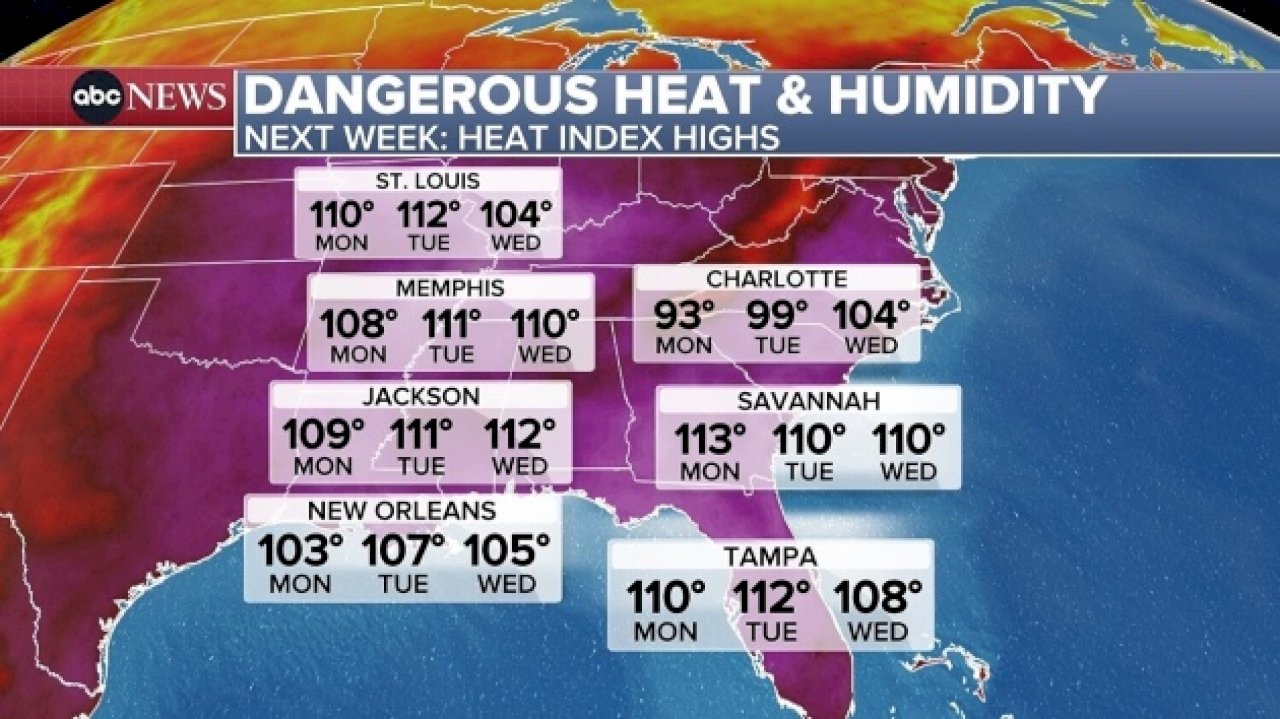
The sweltering temperatures will continue into the weekend and into next week from the Midwest to the Southeast, with heat indices expected to react 113 in parts of North Carolina and 110 from St. Louis to Tampa.
An extreme heat risk is in place from Sunday through Thursday for large portions of the Southeast.
While St. Louis deals with the heat wave, parts of Kansas City, Missouri, are under a flash flood watch on Friday. Some parts were under a flash flood warning early Friday morning with 1 to 3 inches of rain having already fallen by 4:30 a.m.
According to the Kansas City Fire Department, multiple vehicles have been reported in high water and at least 10 water rescues have occurred as of Friday morning.
More rain, from southwest Kansas to central Illinois, is likely to continue through Friday morning, but will break up in the afternoon. However, a redevelopment of this storm is expected later in the day on Friday, bringing additional heavy rain overnight and possible flooding for some of the areas already hit earlier in the day.
During these extremely warm temperatures, the National Weather Service recommends those in impacted areas “limit outdoor activity, stay hydrated and ensure access to air-conditioning and other cooling areas.”
For tips on how to stay safe in a heat wave, click here.
Copyright © 2025, ABC Audio. All rights reserved.

Top popular

Ingram man charged with murder after fatal shooting

Kerr Crime Stoppers offering reward up to $5,000 for information in last week’s non-viable school threat

KISD asks parents to communicate with children about words and actions after ‘copy cat’ threat note found at middle school

City of Kerrville Parks and Recreation reminds citizens that a Red Flag Warning is in effect until further notice

City of Kerrville says that May 7 General and Special Elections will proceed