Listeners:
Top listeners:
-
 play_arrow
94.3 Rev-FM The Rock of Texas | Where Texas Rocks
-
 play_arrow
99.1 The Buck Texas Country's Number 1 Country
-
 play_arrow
103.7 MikeFM Your Texas Hill Country Mix Tape
-
play_arrow
KERV 1230 AM
-
 play_arrow
JAM Sports 1 JAM Broadcasting Sports 1
-
play_arrow
JAM Sports 2 JAM Broadcasting Sports 2


Thunderstorms, flash flooding threaten millions in south-central US
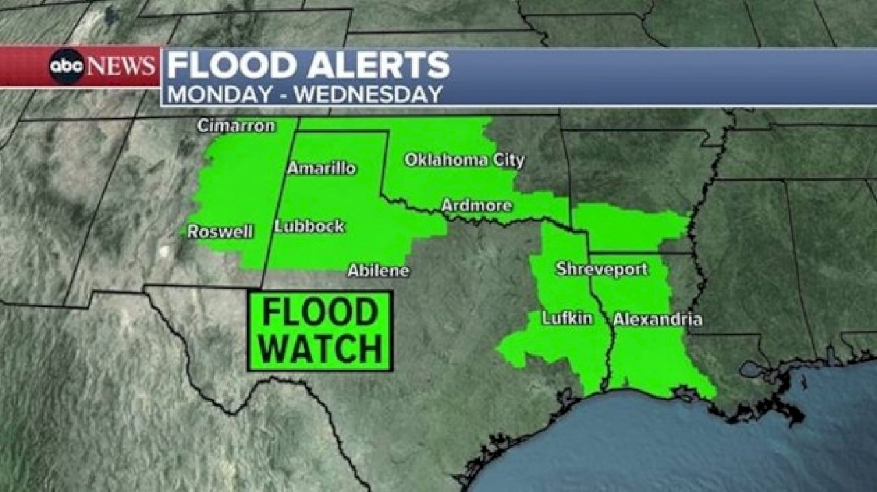
(NEW YORK) — A severe weather threat looms across the south-central U.S. on Monday, from western New Mexico to Louisiana, with 7 million people under flood watches due to potentially heavy rainfall.
There were 50 storm reports — including damaging wind and hail — reported across 10 states on Sunday. Most of the severe storms impacted parts of the Southwest, specifically in New Mexico and Texas.
On Monday, parts of far southeast New Mexico through west and central Texas could face an even larger threat for severe weather with damaging winds, large hail and tornadoes possible in these areas.
The regions could be faced with flash flooding and frequent lightning due to stronger, slow-moving thunderstorms with torrential rain. Both the Texas Panhandle and New Mexico could see 1 to 2 inches of rain, but totals locally could reach 3 inches or more through Tuesday morning.
Along with storms in the South, strong to severe storms could appear along the East Coast following rainfall over the weekend.
A marginal risk for severe storms is possible across portions of the Mid-Atlantic and northeastern North Carolina, with parts of the New York City metro area, Long Island, Lower Hudson Valley, Connecticut, northern New Jersey and northeastern Pennsylvania now under a slight risk for flash flooding on Monday into Tuesday.
A portion of the Florida East Coast could also see isolated severe storms, brining damaging winds, hail and possible tornadoes.
On Tuesday, the system will continue to hit the central U.S., bringing another round of thunderstorms and heavy rain to portions of the Plains and the South. Over 17 million people are under a slight risk for severe storms beginning Tuesday afternoon and evening, with damaging winds, large hail and a few tornadoes possible.
Parts of the Deep South and eastern Texas will face the greatest threat for flash flooding.
Up to 6 inches of rain is expected along the lower parts of the Mississippi River, with 1 to 3 inches possible across parts of north Texas, the Texas Panhandle and Oklahoma. Some of these areas have already seen significant rainfall over the past week, making the ground very saturated and allowing for flash flooding to develop when heavy rain falls.
Scattered showers and thunderstorms will continue to move across the Northeast and Florida peninsula on Tuesday.
Copyright © 2025, ABC Audio. All rights reserved.


Top popular

Ingram man charged with murder after fatal shooting

Kerr Crime Stoppers offering reward up to $5,000 for information in last week’s non-viable school threat

KISD asks parents to communicate with children about words and actions after ‘copy cat’ threat note found at middle school

City of Kerrville Parks and Recreation reminds citizens that a Red Flag Warning is in effect until further notice

City of Kerrville says that May 7 General and Special Elections will proceed