Listeners:
Top listeners:
-
 play_arrow
94.3 Rev-FM The Rock of Texas | Where Texas Rocks
-
 play_arrow
99.1 The Buck Texas Country's Number 1 Country
-
 play_arrow
103.7 MikeFM Your Texas Hill Country Mix Tape
-
play_arrow
KERV 1230 AM
-
 play_arrow
JAM Sports 1 JAM Broadcasting Sports 1
-
play_arrow
JAM Sports 2 JAM Broadcasting Sports 2


Over 25 million under alert for severe weather, flash flooding in Northeast
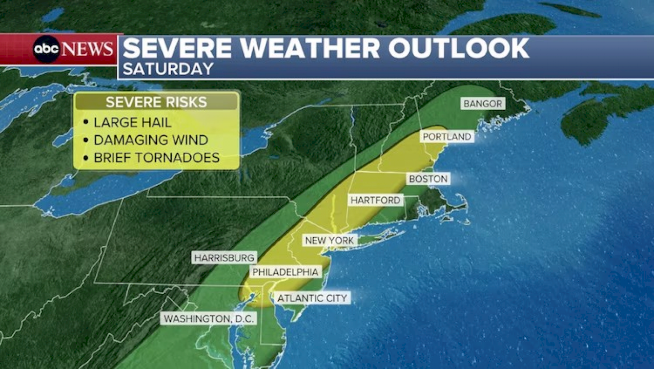
(NEW YORK) — The threat for severe weather on Saturday is shifting east, putting more than 25 million people on alert from eastern Pennsylvania up into southern Maine.
This includes Philadelphia, New York City; Allentown, Pennsylvania; Poughkeepsie, New York; Hartford, Connecticut; Manchester, New Hampshire; and Portland, Maine.
A Severe Thunderstorm Watch has been issued from Maryland to Maine, until 8 p.m. This includes much of the I-95 corridor, including Baltimore, Philly, NYC, and Boston.
In the coming hours, scattered strong to severe thunderstorms will be developing near and along a cold front that is sweeping across the region Saturday afternoon.
The primary hazard from any severe thunderstorms that develop is strong, potentially damaging wind gusts. Isolated large hail and a brief tornado or two cannot be ruled out, especially for locations in northern New England included in the watch.
Any slow-moving thunderstorms with torrential rain could also trigger localized flash flooding, especially in urban, poor-drainage areas, and bring frequent lightning.
Damaging winds, large hail, and lightning will be possible early Saturday evening into the overnight across this area, with a slim risk of a few brief tornadoes.
Flash flooding will also be a concern for some of these areas, with the highest risk (Level 2 of 4) stretching from Philadelphia to Bridgeport, Connecticut.
Multiple rounds of heavy rain from overlapping and training storms will be capable of producing localized to scattered areas of flash flooding, especially with the heaviest downpours or in areas known to flood.
These storms will begin firing off after noon on Saturday and continue into the overnight hours.
The inclement weather is expected to hit Philadelphia to New York City from 2 to 8 p.m., with some lingering rain into the overnight; Poughkeepsie and Hartford up into Springfield, Massachusetts, as early as 2 p.m., continuing to about 6 to 8 p.m.; and Portland down to Boston from 4 to 10 p.m., with heavy rain continuing overnight.
Boston is not facing the highest threat for flash flooding or severe weather, but strong storms are expected to roll through the area.
Rain showers will continue to linger into the first half of Sunday as this cold front continues to move through the region, with the region drying out Sunday afternoon into the early evening.
Behind the cold front that is triggering these storms will be noticeably cooler air for Sunday.
Copyright © 2025, ABC Audio. All rights reserved.


Top popular

Ingram man charged with murder after fatal shooting

Kerr Crime Stoppers offering reward up to $5,000 for information in last week’s non-viable school threat

KISD asks parents to communicate with children about words and actions after ‘copy cat’ threat note found at middle school

City of Kerrville Parks and Recreation reminds citizens that a Red Flag Warning is in effect until further notice

City of Kerrville says that May 7 General and Special Elections will proceed