Listeners:
Top listeners:
-
 play_arrow
94.3 Rev-FM The Rock of Texas | Where Texas Rocks
-
 play_arrow
99.1 The Buck Texas Country's Number 1 Country
-
 play_arrow
103.7 MikeFM Your Texas Hill Country Mix Tape
-
play_arrow
KERV 1230 AM
-
 play_arrow
JAM Sports 1 JAM Broadcasting Sports 1
-
play_arrow
JAM Sports 2 JAM Broadcasting Sports 2


Huge waves slam West Coast as storms continue
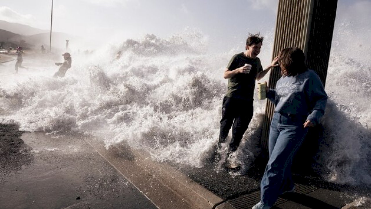
Much of the West Coast continues to face hazardous coastal conditions on Sunday, including 20- to 30-foot waves slamming waterfront communities.
Coastal impacts are expected Sunday along nearly the entire length of the West Coast, from Southern California to the Northwest states, as a series of storms fuel widespread dangerous rough surf.
The latest storm system has moved into the Pacific Northwest, bringing another round of rain and mountain snow from Northern California to Washington and Oregon.
But the primary concern on Sunday will be focused on the persistent rough surf and large waves across much of the West Coast amid back-to-back storms.
High surf alerts remained in effect on Sunday along much of the West Coast.
Dangerous, large breaking waves of 20 to 30 feet in height are expected to continue along the Northern California, Oregon and Washington coasts before easing on Monday.
The large waves will create hazardous conditions along the coast, with waves inundating beaches and potentially bringing significant beach erosion and damage.
Periods of rain along the Pacific Northwest Coast will spread inland across the Intermountain West and Northern California.
Some of the highest elevations of the Cascade Mountains could see some snow as well.
Meanwhile, a new system is expected to bring more unsettled weather to the Pacific Northwest Coast by early Wednesday.
Heavy rain in southeast Texas
Widespread showers and storms are forecast across southeastern Texas on Sunday, with isolated downpours possible.
Localized flash flooding could develop where the heaviest rain moves through, including metropolitan Houston, Galveston and Freeport.
Rainfall totals of 1 to 2 inches are forecast across the region, with isolated amounts up to 4 inches possible through Sunday night.
Storms in southeast Texas are expected to bring heavy rain, with 1 to 2 inches possible across most of the region and some areas receiving 4 to 6 inches.
The weather system hitting southeast Texas is also bringing windy conditions along the coast, with gusts of up to 40 mph possible, leading authorities to warn residents about the potential of falling tree limbs and scattered power outages.
Copyright © 2026, ABC Audio. All rights reserved.

Top popular

Ingram man charged with murder after fatal shooting

Kerr Crime Stoppers offering reward up to $5,000 for information in last week’s non-viable school threat

KISD asks parents to communicate with children about words and actions after ‘copy cat’ threat note found at middle school

City of Kerrville Parks and Recreation reminds citizens that a Red Flag Warning is in effect until further notice

City of Kerrville says that May 7 General and Special Elections will proceed