Listeners:
Top listeners:
-
 play_arrow
94.3 Rev-FM The Rock of Texas | Where Texas Rocks
-
 play_arrow
99.1 The Buck Texas Country's Number 1 Country
-
 play_arrow
103.7 MikeFM Your Texas Hill Country Mix Tape
-
play_arrow
KERV 1230 AM
-
 play_arrow
JAM Sports 1 JAM Broadcasting Sports 1
-
play_arrow
JAM Sports 2 JAM Broadcasting Sports 2


Severe weather hits northern Plains as major heat wave set to move across country
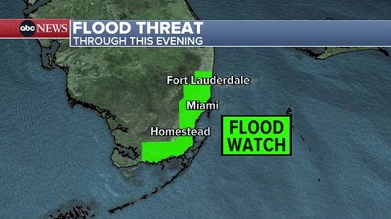
(MIAMI) — Even though the bulk of the rain has wrapped up across South Florida, a Flood Watch remains in effect for more than 4 million people from Fort Lauderdale to Key Largo, including Miami.
Typically, scattered showers in Florida are no big deal, but with so many locations recently picking up 1 to 2 feet of rain, any showers today could lead to more flooding. Looking ahead, the risk for additional flooding will continue to decrease in the coming days.
Over the last seven days, Miami and Fort Lauderdale have both officially seen more than 14 inches of rainfall.
Sunday is finally looking like a “mostly” dry day for the South Florida region, although there is always a chance for a pop-up thunderstorm for this area.
Today’s severe risk
This afternoon and evening, severe thunderstorms are likely in two areas of the northern Plains, including cities like Des Moines, Iowa; Omaha, Nebraska; Bismarck, North Dakota; Rapid City, South Dakota; and Minot, North Dakota.
Damaging wind, large hail, and scattered tornadoes are all possible in this area as the afternoon progresses into the overnight hours.
Dangerous heat expands
This weekend, Excessive Heat Warnings are in effect across parts of the southwest as temperatures soar into the 100s in cities like Phoenix, Arizona; Tucson, Arizona; El Paso, Texas; and Las Vegas.
That heat expands eastward in the coming days, leading to a potentially record-breaking stretch of brutal heat for dozens of cities.
On Sunday, the heat reaches the Heartland and Midwest, with cities like St. Louis, Missouri; Nashville, Tennessee; and Little Rock, Arkansas, all facing record temperatures approaching 100 degrees.
The National Weather Service in Pittsburgh has already issued an Excessive Heat Watch, in effect from Monday morning through Friday night, calling this a “prolonged, potentially historic heat wave.”
On Monday, the Extreme Heat Risk covers Kansas City, Missouri, St. Louis, Missouri, and Des Moines, Iowa.
The brutal heat on Tuesday reaches the east. Record highs are likely in dozens of cities from Ohio to Vermont as temperatures soar into the mid/upper 90s.
Not only does the heat continue to expand later in the week, but the numbers keep going up. Highs could be approaching 100 in cities like Pittsburgh, Pennsylvania; Hartford, Connecticut; and Concord, New Hampshire.
In the tropics
Despite a very quiet start to the 2024 Atlantic hurricane season, there is some potential activity on the horizon. The National Hurricane Center is watching an area around the Bay of Campeche in the Gulf of Mexico, and it currently has a 50% chance of tropical development over the next seven days.
If this blob lives up to its potential, it could become the first named storm of the year, which would be Alberto.
The conditions in the tropics this summer are worrisome, with both the ocean temperatures and atmospheric conditions primed and ready to produce storms. There is no guarantee that it’ll be a record-breaking year, but it’s still very early in the season and things can ramp up quickly.
Copyright © 2024, ABC Audio. All rights reserved.

Top popular

Ingram man charged with murder after fatal shooting

Kerr Crime Stoppers offering reward up to $5,000 for information in last week’s non-viable school threat

KISD asks parents to communicate with children about words and actions after ‘copy cat’ threat note found at middle school

City of Kerrville Parks and Recreation reminds citizens that a Red Flag Warning is in effect until further notice

City of Kerrville says that May 7 General and Special Elections will proceed